

Goofing around with a 30 dollar vector network analyzer i got around ThanksKilling on ebay when I got really high on edibles.
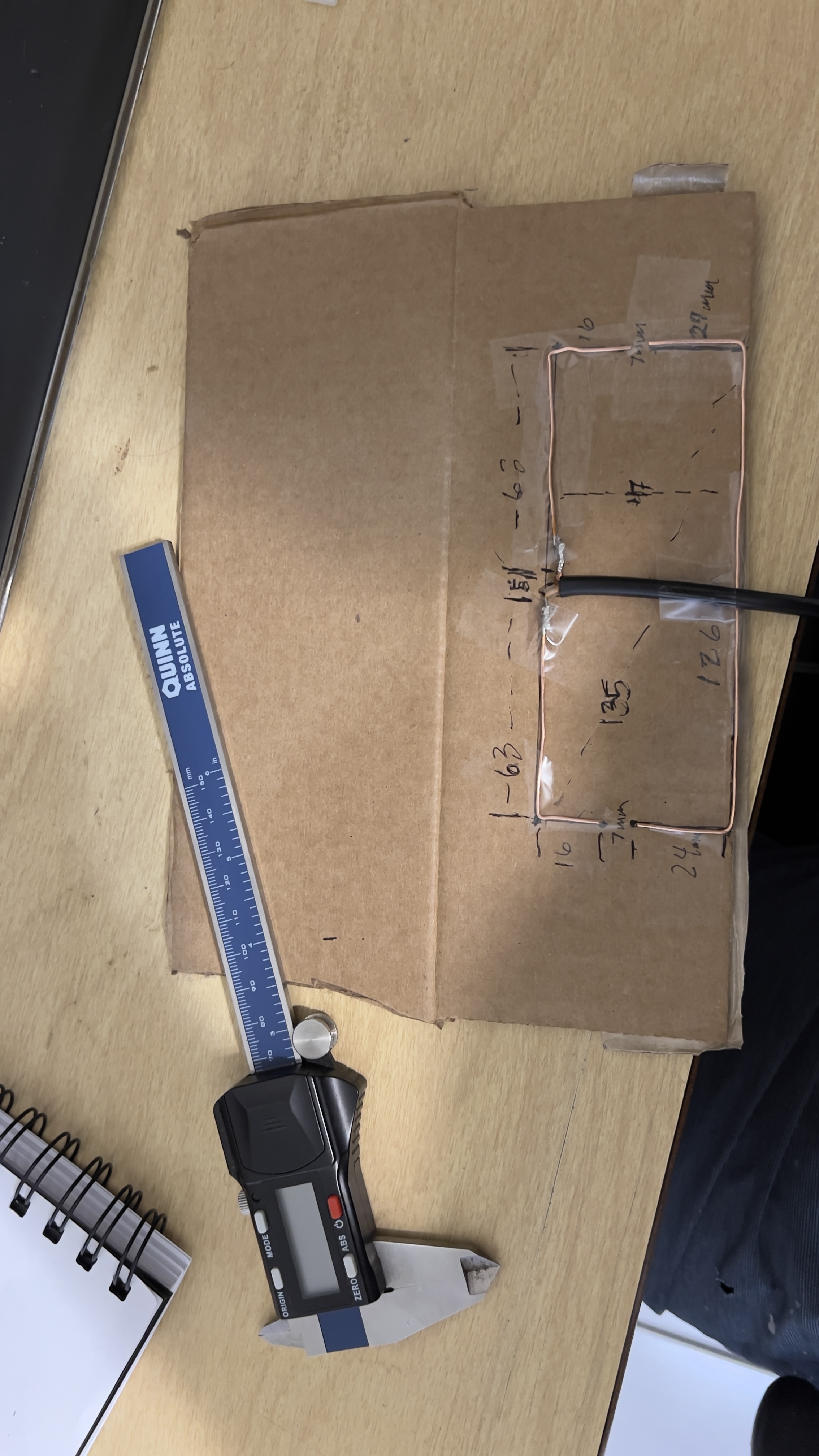
Im an absolute rook when it comes to RF, RF theory, antenna building, etc. i follow calculators that others have created for rookies like me. That said, there is a water tower about a half mile from my house that has a repeater for the local counties that are tied in to a EMS system. im working my way towards having a setup to follow the trunked radio system, decode it and allow me to listen to it. im “teaching” myself enough CAD to be passable when nobody who knows more is in the room, and am making a frame for the antenna so I can print it in ABS and mount my antenna outside eventually.
i followed a calculator i found online, and built
This is the results - my first photo is a sweep from 50khz - 1ghz. my VNA is only 30 bucks after all, so it has a very small resolution. I can do a broad sweep with about 100 data point, find its harmonics, then narrow down sweeps to get finer details. my second photo is were my SWR was the lowest. I didnt quite nail it, its resonant a little north of 853, which is my intended frequency, but even still im at 1.2 swr which is good as to my understanding. i had the logmag function set to a different input on the VNA so the measurement here is wrong in the second screenshot. it is correct in the first one.
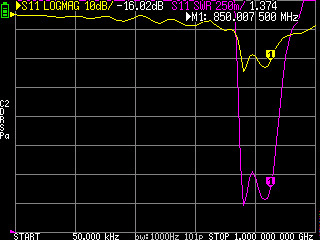
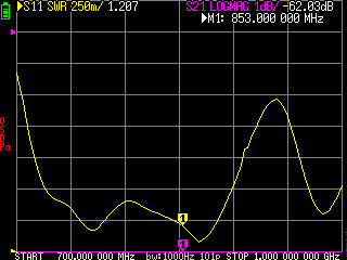
SWR, I think t,his is a ratio of power transmitted to power broadcasted at the antenna. 1:1 is ideal. here its about 1.2:1 which is pretty good. needs to be under 2.5:1 as ideal. logmag shows what frequencies my antenna is good for lower -dB is better, here its tuned to about 750mhz-875mhz. everything below and above that is pretty well rejected. I think. like i said, im a rookie. im watching all sorts of stuff and reading everthing i can, because i want to test for my Amateur Technicians license next year. i imagine antenna theory and the like ties in to this somehow.
anywway, i did a thing, and wanted to show someone. anyone who knows more than me and feels like correcting what i got wrong please do so, but please be kind. Im just starting to feel like im getting the hang of the smallest thing, and dont want to be discouraged too badly.
thanks. this is actually the second one ive done this with. my first one was a QFH antenna for picking up NOAA APT and METEOR LRPT images. i made that one out of 3/4” copper water line and 2” sch 80 pvc I had in the garage (im a plumber so it was the things i had the most of at the time) i adjusted one element on it, and got it to about 1.4 swr on 137 mhz before i gave up and left it as it was. I was starting to warp the pvc from the heat, sweating and resweating copper over and over.
aye nice I've always been kinda curious about picking up weather satellites but I just don't have the time or energy for one-off projects rn
Ive got APT, and LRPT pretty well licked at this point. I ha e a thin client setup to record, decode, and put the images in folders so i can view them. Im setting my sights on GOES & the international geosynchronous satellites in general next. They all communicate with eachother somewhat and apparently i can get pictures from the Japanese geosynchronous satellites amongst others via the US ones pointed at me. I really want to pick up some of those sweet sweet full disk pictures that come from those geosynchronous satellites. Im keeping my eye out for a junk satellite tracking platform i can repurpose to follow the NOAA satellites and pull HRPT data off them. Hand tracking satellites is a PITA i hear.
Anyway, thanks for coming to satellite talk.