
cus at first blush, it seems like a really sensible suggestion and i myself cannot think of any fault with it in principle
Transcript:
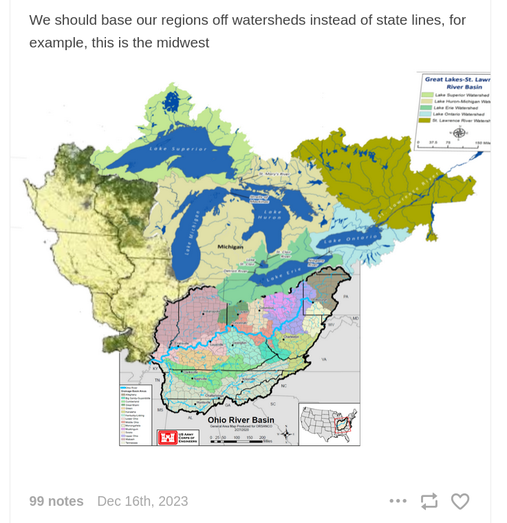
We should base our regions off watersheds instead of state lines, for example, this is the midwest [diagram of the Great Lakes–Saint Lawrence River Basin]
https://amtrak-official.tumblr.com/post/736885520460906497/we-should-base-our-regions-off-watersheds-instead
There are also climatic regions and cultural regions and historical regions though, which makes this way too simplified. I will argue for northern Kentucky, esp Louisville, as being part of the Midwest, but this is for historical/cultural reasons. But the core of Appalachia as part of the Midwest? No. Tennessee also makes no sense.
Also that map is weird. The Great Lakes flow into the North Atlantic by way of the st Lawrence river, the Ohio flows into the Mississippi and ultimately the gulf. There are two watersheds that are really part of much larger watersheds (st Lawrence and Mississippi). Not sure which is supposed to be the Midwest but based on this map the core of what we consider the Midwest today would actually be part of a different region than Cleveland, Detroit and Chicago
edit: wait, is it just me or does this map make no sense. Where is the Mississippi watershed? Surely they're not implying that minneapolis is part of the lake michigan watershed?
edit 2: okay okay, it looks like the mississippi watershed is like the same color as the huron-michigan watershed except topographical or something. And also I just didn't realize how close the borders of the mississippi watershed come to lake michigan. Map makes sense, although the labeling could be better.
edit 3: furthermore, the post is wrong because they're saying regions should be based off watersheds, but they're using two watersheds and the upper half of a third to define the "midwest." I'm not sure if they're saying the great lakes or the Ohio watershed could be considered the "midwest," but neither makes sense to me. If the Ohio watershed is the midwest, then appalachia is part of the midwest while detroit, cleveland, chicago and milwaukee are not. If the great lakes/st lawrence is the midwest, then most of Ohio and Indiana, including Cincinnati and Indianapolis, are not the midwest, while Montreal and Quebec City are the midwest. And furthermore, if watersheds are how we define regions, Minneapolis and New Orleans are part of the same region.
Furthermore, how do we define watersheds? The map is showing three watersheds, but really the Ohio river watershed is part of the Mississippi watershed. So is the entire Mississippi watershed part of one region, including the Missouri and Ohio watersheds? That would be a gigantic region. Or are we splitting them up, which begs the question, if we're splitting up the watersheds, why not split them into even smaller watersheds? Why not have the Salt River tributary as a region and the Tennessee River as another?
But really this map is showing one watershed since ultimately all of this water flows into the Atlantic. So why not have everything east of the continental divide as a single region? You can see how complicated things get.