
Apologies. This might not be the perfect community for the post.
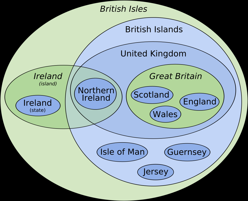
This chart: "England, Scotland and Wales are in Great Britain"
Wight, the Scillies, Anglesey, Sheppy, Anglesey, the Shetlands, the Orkneys, the Hebrides, and thousands more: "Are we a joke to you?"
I think Sheppey is a joke to everyone including the people that have to live there.
I’m trying to remember though, aren’t the Jersey, Guernsey, and Man somehow closer to Scotland or Wales status than say Sheppey or the Orkneys?
Yeah, the channel islands and the Isle of Man have more autonomy. Officially they are "self-governing British Crown Dependencies".
Jersey and Guernsey have different VAT rates for instance. For years, play.com was based in Jersey solely so they wouldn't have to pay VAT on most of the cheaper stuff they sold to the mainland.
A quiet little tax haven full of polite stuffy old people. I'm thinking of visiting the new one, I assume it's much the same?
The Republic of Ireland and Northern Ireland should pull an epic gamer move and simplify this chart.
Now if someone can tell me what exactly "Britain" is? People say it all the time, like this is the largest statue of a vulva in Britain. Just shorthand for Great Britain, or is it something else?
Just that - shorthand for Great Britain. Easier to use when you don't think it's so great, like if you live in the Republic of Ireland!
Republic of Ireland
Which on the diagram is coterminous with “Ireland (state)”?
Exactly - that's it's proper name and how it's distinguished from Northern Ireland since they share the land mass of Ireland
You did a great job on this though, OP. It's difficult to explain to non-nationals with no idea of the history, so this is very helpful
I’m not sure I follow. It looks as specific in the diagram as all the other names?
It's not an actual term that is used though. "Great Britain" and "Ireland" are the names of the islands, "the United Kingdom" and "(the Republic of) Ireland" are the names of the sovereign states, "the British Isles" is (one) name for all the bits of land. "British Islands" is not an official term or one that anyone uses.
This is a good way to distinguish the terms. I wonder if there is a good colour scheme to also indicate the nation states as district from the landmasses
So I'm late to the party here, but this is a very early version of a diagram I'm putting together that corrects a couple of issues with the diagram OP posted.
*removed externally hosted image*
As I said: very early and also very incomplete, but what's there is accurate.
