
- cross-posted to:
- urbanism
- cleveland@midwest.social
cross-posted from: https://hexbear.net/post/412448
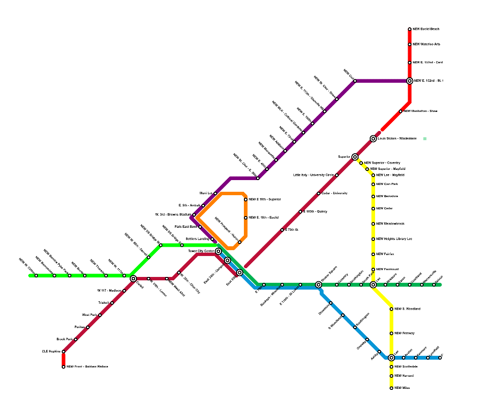
Early this year, I created an RTA expansion map proposal that I shared to Reddit and Mastodon. I got a lot of feedback, and in the mean time I've learned more about modern rail construction in the US and analyzed the city more closely. I've put together a new proposal that starts fresh, coming to a lot of the same conclusions but also doing some things very differently. I want to break down each section here and get some input to keep improving it.
Red Line Expansion West
ShowFirst, expanding Cleveland's flagship rail service and busiest transit line. On the west side, I propose the addition of two new stations, one infill and one extension. After Hopkins, I suggest extending a fresh stretch of line. 2 miles of this would run on current rail, and then it would convert to a streetcar for another half mile down Front Street to connect to central Berea and BW's campus. This touches on a few themes I'll come back to: First, taking advantage of the incoming rolling stock's ability to seamlessly shift from mixed traffic to street level to grade separated. Second, bringing educational institutions into the rail network. Additionally, I'm proposing an infill station at W.43rd, because the gap between the W. 25th and W. 65th stations is way too huge.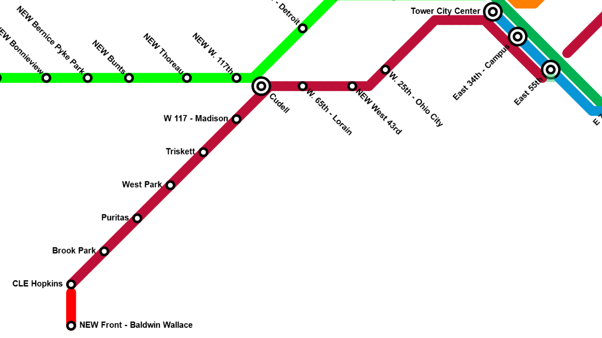
Red Line Expansion East
ShowOn the east side, I'm suggesting a much more substantial expansion of the Red Line. I suggest that, after Stokes, it continue on that rail spur, with a station at Shaw (close to the high school), then turning up 152nd. Here, it should be new, elevated rail. There are a number of points in this where I suggest the tall but valuable task of fresh elevated rail lines. That would run along 152nd (with stops at St. Clair [Colinwood HS gets service here] and Cardinal) before turning onto Waterloo, hitting the arts district, and then turning back north somewhere between 156th and 164th to run to Euclid Beach Park. Collinwood, especially North Collinwood, is very disconnected from the city in terms of transit. There's also very little transit service to the lake. This seeks to remedy all that.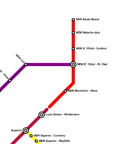
Waterfont Loop
ShowWhen the Waterfront line was originally built in the 90's, it was supposed to turn back south through downtown and form a loop. I say, let's finish that loop. I suggest going down E. 18th. I know that might seem a little odd, but it neatly hits Playhouse Square and CSU. Then, turn it onto Prospect to hit the Q and the Progressive before taking it down into Tower City. The whole additional stretch here is elevated. I'm also separating this out more cleanly from the Blue/Green Lines and making it definitively its own thing. I see it operating two ways: One, with a regular, dedicated looping service. Second, taking advantage of interoperability to allow any other line hitting TC to add a loop through downtown on some service. For example, if the Red Line were running 6 times an hour, one or two of those would additionally run the whole downtown loop. You could get very, very high frequency on this loop by combining these two options, or even with just the second.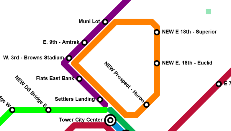
Green Line Expansion West
ShowIt's time to make the Detroit Superior Bridge a subway bridge again. Currently, there are two inaccessible stations at either end of the bridge, and then a tunnel that runs along Detroit to W. 28th. I suggest connecting Tower City's lines underground to the bridge, renovating both bridge terminal stations, and, where the tunnel ends, bringing the line up out of the ground onto new elevated construction. There, it runs above Detroit until connecting into Cudell. Here we hit another theme of my proposal: lines connect far outside of Tower City. This provides a great deal of resiliency to the network as a whole. There's also an alternative option where, instead of going above Detroit, the line turns north immediately after the bridge to hit Whiskey Island and Edgewater, then connecting into Cudell. This would use current rail ROW that could either be taken from NS or built above with elevated rail. Either way, after Cudell, this continues on or over that rail through Lakewood, stopping near the edge with Rocky River. It could feasibly go over the river as well, but I'm only extending to inner ring suburbs here. Lakewood service seems absolutely mandatory to me given its density and linearity.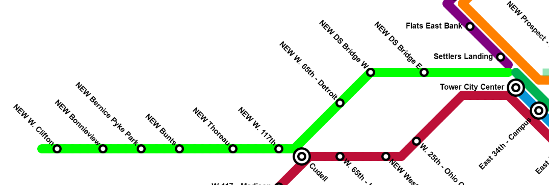
Purple Line
ShowThis is the first of two proposed completely new lines. It comes off the Waterfront line/loop as a spur. It carries briefly along established rail ROW moving above St. Clair as elevated rail at E. 36th, by Tyler Village. It then runs entirely over St. Clair, stopping every half mile to a mile, until connecting to the Red Line's new St. Clair - W. 152nd station. Again, I'm focusing here on satellite redundancy, hitting underserved areas, and providing good access for students - this line connects to four separate high schools. Taking advantage of interoperability, these trains could continue north onto the Red Line's lakeward extension. This line also serves Asiatown, which is due for rail connection.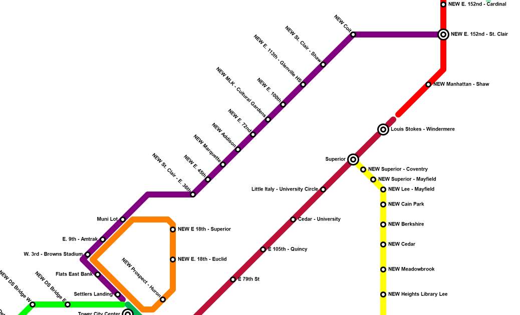
Yellow Line
ShowAfter Lakewood, Cleveland Heights is the most densely populated city in the state. It's a traditional street car suburb squeezed between RTA's current rail lines. I propose here a mostly street-running streetcar that would link Red, Green, and Blue lines. It hits CH's main cultural institutions, provides further connections for East Cleveland, and brings rail into underconnected Southeast Cleveland. Where possible, I'd be happy to see this as elevated rail, but I think this is one of the few areas where a streetcar is appropriate (even if it's in mixed traffic for most of its time on Lee). This hits CH and SH high schools. It unlocks a huge variety of interoperability options: direct connections to downtown, a variety of looping east side services, massive system redundancy, etc.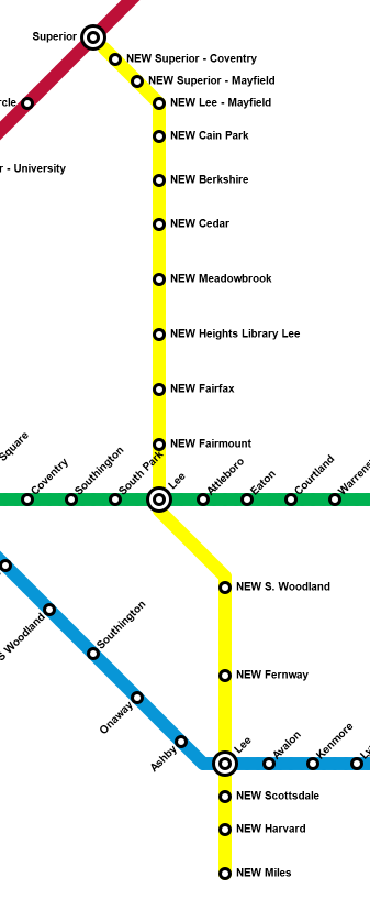
So, that's my proposal. I think it's pretty good! Two new elevated rail lines, large elevated extensions of current routes, some streetcar service, tons of redundancy and interoperability, and expanded coverage that focuses on dense and/or underserved areas. I know this leaves the immediate south of the city with relatively little service, but I think this ultimately provides more value than southern lines. What's your input? What works, what doesn't? Is there any way that any portion of this is at all feasible, or am I living in a realm of pure fantasy?
You must log in or register to comment.
Hey, I like it but Im a sucker for trains so I don't have to drive anymore. If anything, I wish that RTA would actually work regionally and run the lines to the edges of the county to enable true car-less mobility in a city built for it.
