
Hello and warm greetings to my fellow news mega enjoyers and to the wider hexbear, lemmygrad and lemmy.ml community,
I've been finding myself browsing the newsmega often and was often thinking of a way that would help me contextualize the discussions and news that I'm reading. I remembered an atlas I had in school that would show the location of industries and natural ressources (and more) and decided try to recreate a digital version similar to https://atlas.cid.harvard.edu/. When I stumbled upon lemmy-js-client I found a fun way to display lemmy comments geographically, which I would like to share with you:
https://hex-atlas.netlify.app/
⚠️ Spoiler Tags are not implemented thus CWs are not hidden
Nexus Features:
- @SeventyTwoTrillion@hexbear.net Bulletins
- Hexbear Reading List (Thank you @CARCOSA@hexbear.net for the suggestions)
- ProleWiki (Thank you Lemmygrad for maintaining this)
- Wikipedia/Natopedia
- Anarchist Library
I'm open for suggestions, but would like to continuously add new features:
- Mastodon.social (well documented)
- Marxists.org (will be difficult)
Moon of Alabama (looks easy)(Thank you @someone@hexbear.net for pointing out the transphobia)- Usability and performance improvements
- and maybe more cool features where the guiding ideas are: "IRL Victoria 3 UI" and a "cockpit for newsmega-enjoyers" (e.g. comparing regions and seeing commodity/capital flows, real-time 1% flight data, vessel data - to enjoy the ansar allah blockade, virgin chad ranking, etc.)
Basic usage:
-
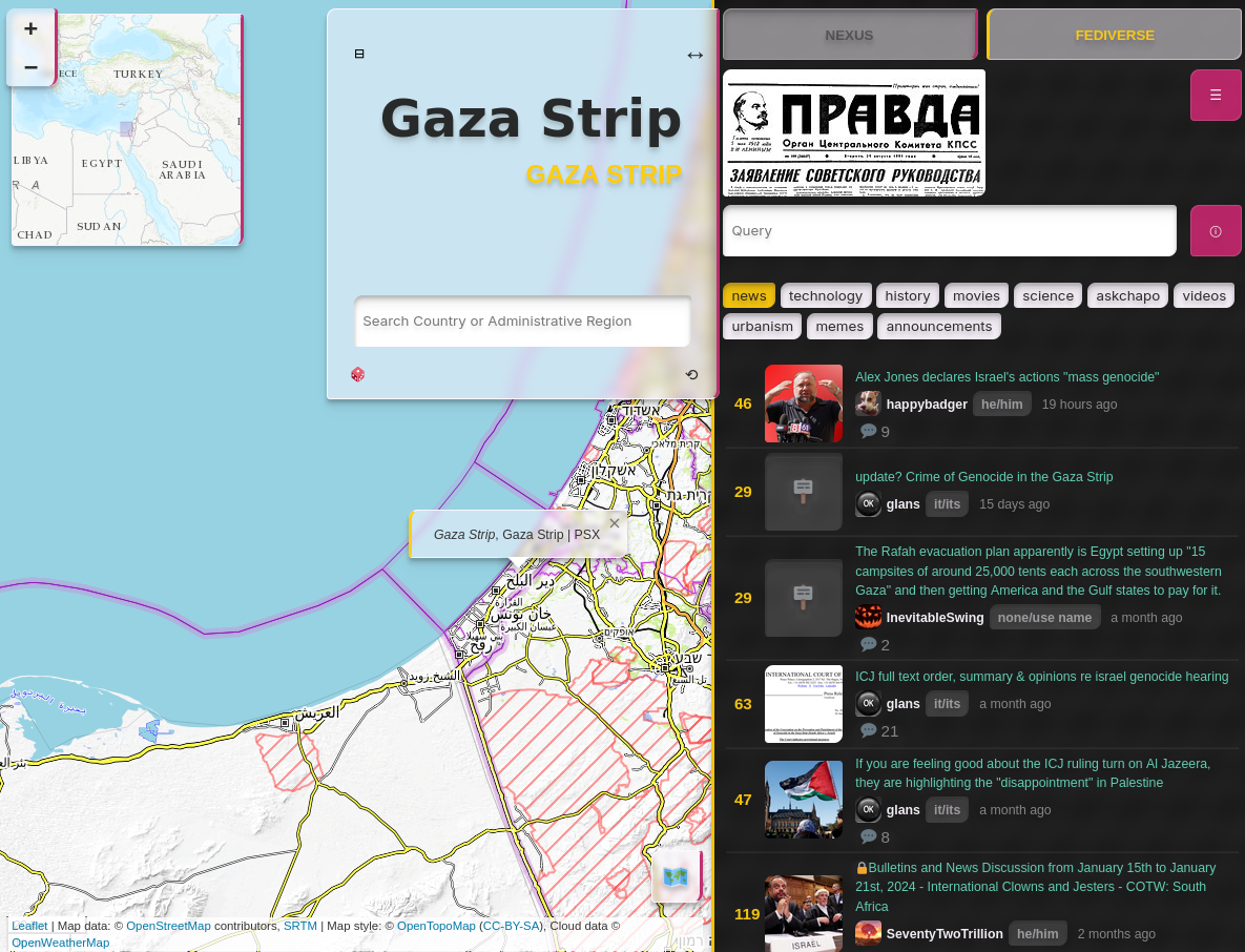
You can either search for a place or click on it. You'll see various scopes: provinces/territories, countries, intermediate regions, sub regions, continent. You can click also on these to change the scope. What it actually does is send it as a search query into lemmy and you see the search results to it (I built a fancy search page). IN the Fediverse Tab you can select the instances, sort types, and other settings from lemmy. On the Nexus Tab you have a similar behaviour, just for the various modules. You'll see the wiki of whatever is selected on the map :
-
use query to search location by query e. g. brics and find discussions pertaining to the selected location.
-
the query field can also be used to find and filter content by communities that are not listed
-
on Mobile long press pictures to unblur it (not fully tested) on desktop hover with mouse
tldr: Attention [Pink]: Select an option [Purple] to reveal selected information [Yellow].
It's in a prototype stage so please keep in mind:
-
⚠️ Spoiler Tags are not implemented thus CWs are not hidden ⚠️
-
It's mostly optimized for desktops. Sry comrades with old hardware - no optimization, yet :( @kota@hexbear.net post inspired me to look into this tho.
-
Provinces/Territories: While I was doing manual edits to some regions I realized I'm doing something very political (duh). Following this, I'm looking for solutions to implement user defined regions (if there's interest from you) e.g. #fromTheRiverToTheSea #brics #udssr #whatever Comrade @SleeplessOne1917@lemmy.ml offered help, but I have only experience with front-end and am not sure how and what to propose. All my ideas are leveraging the current state of development and might be annoying to you. If you have experience, suggestions, etc. on how to make this work, feel free to start a discussion, reach out, etc.
-
Provinces/Territories: If you want something particularly aggravating changed asap, feel free to start a discussion and vOtE! I'll update manually.
-
Countries that span two continents are only displayed as belonging to one e.g. Russia - Europe (Dataset used: https://github.com/lukes/ISO-3166-Countries-with-Regional-Codes)
-
Right now this project is exclusive to hexbear, lemmygrad, lemmy.ml and their federated instances. I have an inner conflict: Generally, fuck intellectual property and I would like to make it foss, but this would make it available for lib/chud content as well. Should I? Help me resolve this.
-
No login implemented
Please consider this a tribute to this community, which I've been lurking and a member since the r/CTH days (nevar forget). I started web development not too long ago and am deeply inspired by dev titans among others:
Thank you and the mods and admins for making hexbear/lemmy what it is today.
![]()
Enjoy your weekend :)
(After I post this I will leave the computer for a while and wont be able to really check and respond for a few hours)
Death to fascism
Death to capitalism
Death to imperialism
Trans rights are human rights
EDIT: After some consideration I decided to make the code public under the GNU AFFERO GENERAL PUBLIC LICENSE ( AGPL-3.0 license )
https://github.com/hexatlas/lemmy-atlas/
https://git.altesq.net/hex_atlas/lemmy-atlas/
Very cool, as an GIS dev I like what u did here.
I personally dont like the overview map, i dont think thats really needed and if, than maybe smaller and without any labels (u can use positron from CartoDB for that or just an generalise line layer for coastlines and countries) and down to the left of the screen. Also the generalisation of the polygon layer has some effects that I dont like at Zoom level about 7-1, maybe just make them clickable but invisible at this zoom.
I dont like the topo tile map as default, i would use Esri standard or openstreetmaps or Positron with labels, it is less overwhelming.
And a Idea that I think is really cool would be a point layer with pins of places that someone recently wrote something about on hexbear or lemygrad, maybe the last 24h. That way we would see at the first sight where is something big going on.
Hope that what I wrote was helpful. Thank u for ur great work.
I didn't know GIS development is a thing and I will have to look a lot more into it. Looks like I've been reinventing the wheel. It's the first time I worked with maps and was just screwing around 😅
Do you mean the minimap in the corner or the entire map?
I gave it a quick look and I probably should've used this from the get go. I will see how I can use this in this project (It's written in react-ts)
Thank you I will try to solve this!
It was a purely aestehtic choice (like that cloud layer that disappears when you zoom in) lol I updated the default to be OpenStreetMap
I have an Issue open for "Active Regions". I actually want the map to also auto focus on there and to be able to see a weighting of the entire map based on the amount of comments/posts. I'm not sure on how to achieve this, but could be if I receive amount of search results back from the lemmy-client-js api. e.g. Gaza Strip - x amount of comments and compare it with other regions
Thank you it is! :)
Yeah sorry I ment the minimap. Ur dedication and enthusiasm is really inspiring, honestly u are so cool. <3
When I graduated, GIS wasn't as mainstream. Couldn't find a job in the field and gave up. Years later, its fucking everywhere.
Yeah I got extremely lucky, where I live most of us where fished out of the university before we could even graduate.