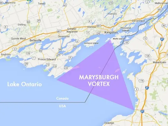
The Marysburgh Vortex is an area of eastern Lake Ontario with a history of shipwrecks during the age of sail and steam which has encouraged legends, superstitions and comparisons to the Bermuda Triangle. The name describes an area whose three corners are Wolfe Island, Mexico Bay near Oswego, New York, and Point Petre in Prince Edward County, Ontario. As many as 500 ships and 40 aircraft have been lost in the vortex.[1]
Although many legends suggest mysterious circumstances for the sinkings, historical writers have attributed the area's record of shipping disasters to conventional maritime hazards such as bad weather, shifting cargoes, fires, submerged reefs exposed during periods of low water levels, and compass errors due to natural geomagnetic anomalies.[2][3]
The Picton
The Picton was a 100 foot wooden schooner built in 1867 in Picton, Ontario to transport goods for trade on Lake Ontario.
Show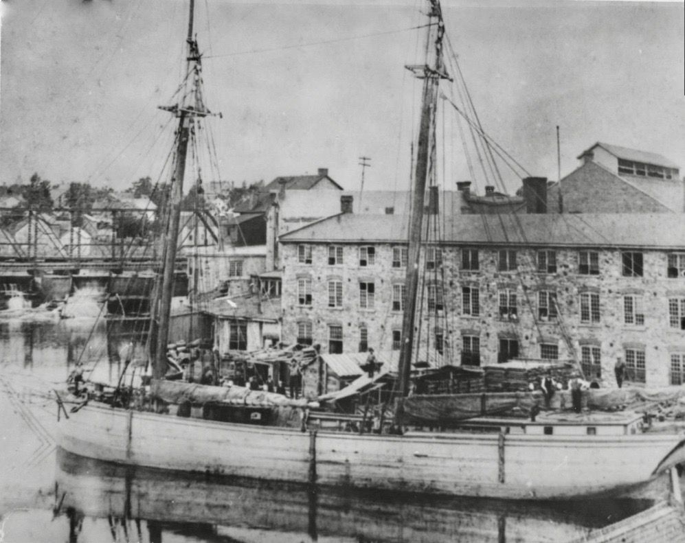
The Picton moored on the waterfront in Gananoque, ON
On the morning of June 29th, 1900, the Picton set sail from Charlotte, NY (now Rochester) with a cargo of coal bound for Kingston, ON. The boat was crewed by Captain Jack Sidley, Frank Smith (mate), Barney Ayres (cook), Walter Dunn, William Cole, and William Bly (deck hands), all of Belleville, ON. Sidley was accompanied by his 11 or 12 year old son, Sylvester, or "Vessy".
The Picton was followed out of Charlotte that morning by another schooner, the Acacia, also bound for Kingston.
Unfortunately for the sailors, the ships were struck by a squall out of the Northwest.
The Acacia crew succeeded in reefing their sails before the approaching storm and scudding through the sustained wind and waves, saving the boat, but the Picton crew must have been unprepared or otherwise unable to take similar precautions, as all their sails were still standing when the storm struck.
Captain Byron Bongard of the Acacia watched as the Picton was battered, unable to help. Heavy winds snapped the main mast. Her topsail was lost and the lower sails were brought down, as if reefing. With her foresail and main sail still up, the ship eventually vanished from sight beyond the "mountains high" waves.
Bongard reported the missing ship upon his arrival in Kingston.
Another third schooner caught by the same storm, the Annie Minnes, reached Belleville soon after, whereupon the Captain Jas. Savage reported he had been within 2 miles of the Picton when he witnessed her "last fatal plunge". When he passed within the Picton's wake, all that remained floating were some loose gratings and a sailor's hat.
Sources differ on details, but some months later a boy is reported to have found Captain Sidley's final message in a bottle.
According to some, a fisherman's son from Sackett's Harbour, NY discovered a ketchup bottle containing a note bobbing in Chaumont Bay off Point Peninsula:
"Have lashed Vessy to me with heaving line so will be found together. - J. Sidley, Picton"
Others attribute the discovery of a message contained in a whiskey flask washed ashore on the south side of Howe Island to a "Theobald F. Clark, the young son of Wilton Clark of Philadelphia, Pa., who owns a summer home at the foot of Long Island":
"John Sidley, Captain of the schooner Picton, in great peril; expect to sink any minute. Good-bye to all friends. Finder please report this to my wife."
The main boom was eventually found by another schooner called Strubenzee, the only other piece recovered at the time.
The wreck of the Picton was eventually discovered around 20 miles west of where the boom had been found, at a depth of 200 feet around 100 fathoms east of Charlotte.
The bodies of the 7 people aboard the Picton were never found.
So why did the eastern end of Lake Ontario become a graveyard for so many wrecks like the Picton?
https://www.shipwreckworld.com/maps/category/lake-ontario
Something lurking beneath the waves may have contributed to their tragic fate...
[Continued below]
[Continued from above]
Charity Shoal Structure
Navigational charts for the region warn sailors of known magnetic anomalies associated with a feature called Charity Shoal:
Show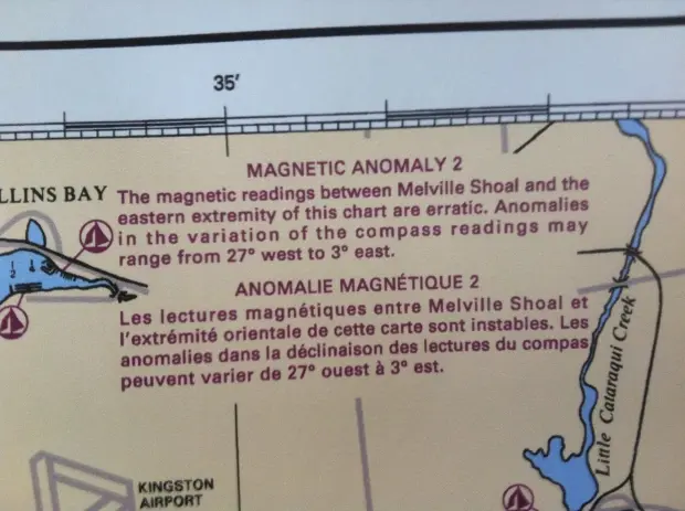
“MAGNETIC ANOMALY: ANOMALIES IN THE VARIATION OF THE COMPASS READINGS MAY RANGE FROM 27degrees WEST to 3degrees EAST”
Show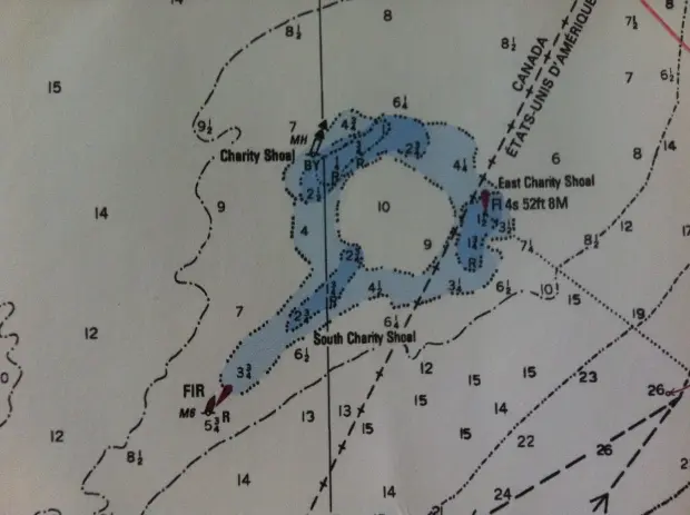
Charity Shoal
Magnetic anomalies like that of the Charity Shoal were once the subject of research by the Canadian and US governments under PROJECT MAGNET. Established by the Canadian Department of Transport in 1950, PROJECT MAGNET saw the Defence Research Board and the National Research Council (NRC) investigating magnetic field disturbances. A similar US study with the same name began one year later, directing the US Navy to continuously collect vector aeromagnetic survey data to support the U.S. Geospatial-Intelligence Mapping Agency.
Show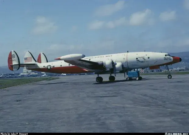 Show
Show
Lockheed Constellation aircraft equipped with highly sensitive electro-magnetic sensing equipment, PROJECT MAGNET marked on the vertical stabilizer
The US PROJECT MAGNET continued until 1994. Findings were assembled to support the work of "scientists performing regional and global geophysical studies, including research into the nature of Earth’s magnetic field," according to the National Geophysical Data Centre.
The NGDC and he National Oceanic and Atmosperic Administration commissioned further study of the Charity Shoal Structure.
Show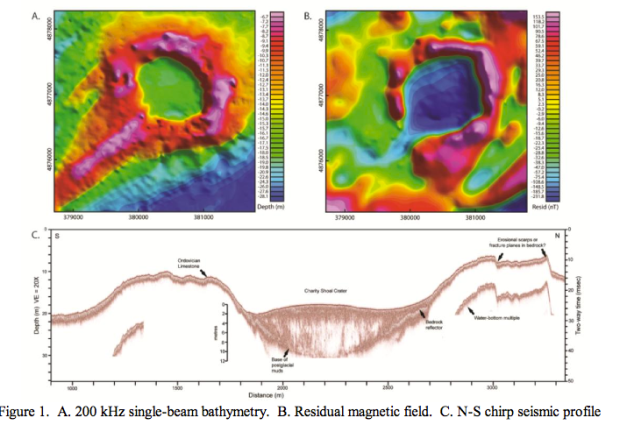
“A small equidimensional circular depression 1000 meters in diameter, with a continuous encircling rim, coincides with the feature referred to as Charity Shoal on nautical charts. An elongated ridge extends southwest from the feature, resembling the tail of a crag-and-tail feature common to some drumlin fields. The basin is slightly deeper than 18 meters and the rim rises to depths of 2-6 meters. The origin of the feature remains unknown. Although a sinkhole in the limestone terrane is a possibility, an origin related to a meteor crater, that was subsequently glaciated, seems more likely. Aeromagnetic mapping by the Geological Survey of Canada revealed a negative magnetic anomaly over Charity Shoal, which is a characteristic feature of simple impact craters.”
In 2013, the Universities Space Research Association, an independent nonprofit research corporation conducted a comprehensive study of the Charity Shoal structure, including creation of a 2-D magnetic model.
Show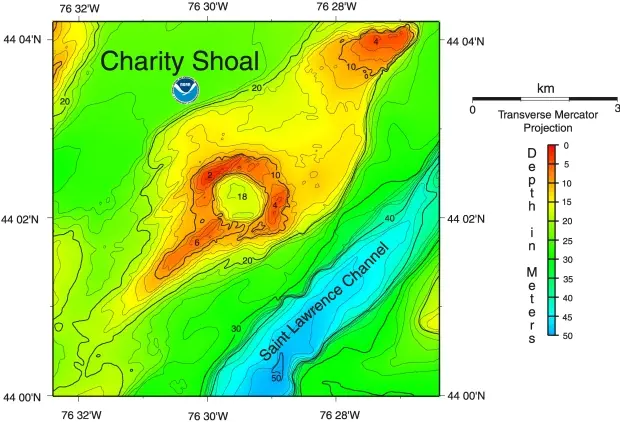 Show
Show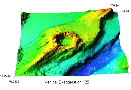
The underwater structure is defined by a ring-like magnetic high and central magnetic low, with the total field magnetic anomaly being quite large, which cannot be accounted for. The study then states “the anomalies large magnitude indicates a deep basin and/or demagnetization effects in the Precambrian basement rocks below the structure.” The conclusion of this study indicates that the structure is “consistent with a meteorite impact”.
“The origin of the CSS is uncertain but it has been interpreted as a an Ordovician age meteorite impact.”
If the Charity Shoal Structure is indeed a meteorite impact crater, that may explain the associated magnetic anomaly - the mineral deposits at impact sites of meteors composed of metals like iron and nickel can emit strong enough magnetic fields to affect navigational instruments.
One nickel-iron meteor crater of comparable size to the Charity Shoal Structure is the Barringer Crater in Arizona:
Show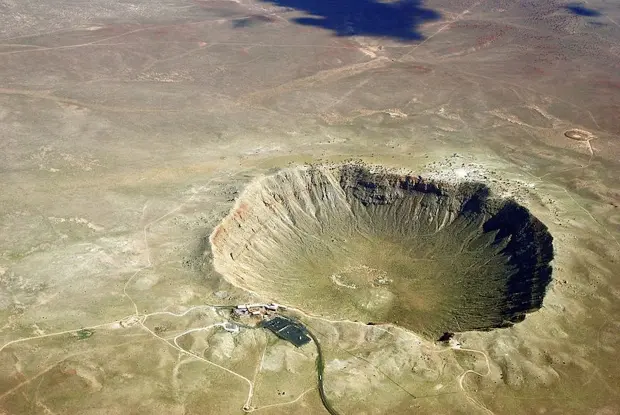
The magnetic anomaly of the Charity Shoal Structure may have contributed to the legend of the Marysburgh Vortex, sending sailors off course into unmapped shoals.
While wrecks are not as frequent as they once were, the Vortex is still claiming lives as recently as 2013, when the 32 foot Persnickety out of Sodus Bay, NY was found adrift without its crew off Prince Edward County with all sails up and no signs of trouble. Closer inspection by authorities revealed the operator’s drivers license, money, food, and even ice in a cooler intact onboard. A three day rescue operation to locate the missing operator of the boat was unsuccessful and the operation was suspended with the reason for the disappearance unsolved.
Show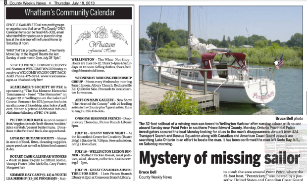
Sources
https://en.wikipedia.org/wiki/Marysburgh_vortex
https://navalmarinearchive.com/research/docs/schooner_picton.html
https://thousandislandslife.com/recording-history-schooner-days-and-the-picton-by-c-h-j-snider/
https://ottawarewind.com/2019/04/16/prehistoric-meteor-impact-site-submerged-under-lake-ontario/
https://ottawacitizen.com/news/local-news/king-did-a-meteor-strike-give-birth-to-the-mysterious-bermuda-triangle-of-the-north

