
Webpage
An extraordinary map of a proposed European Union in 1920! - Rare & Antique Maps
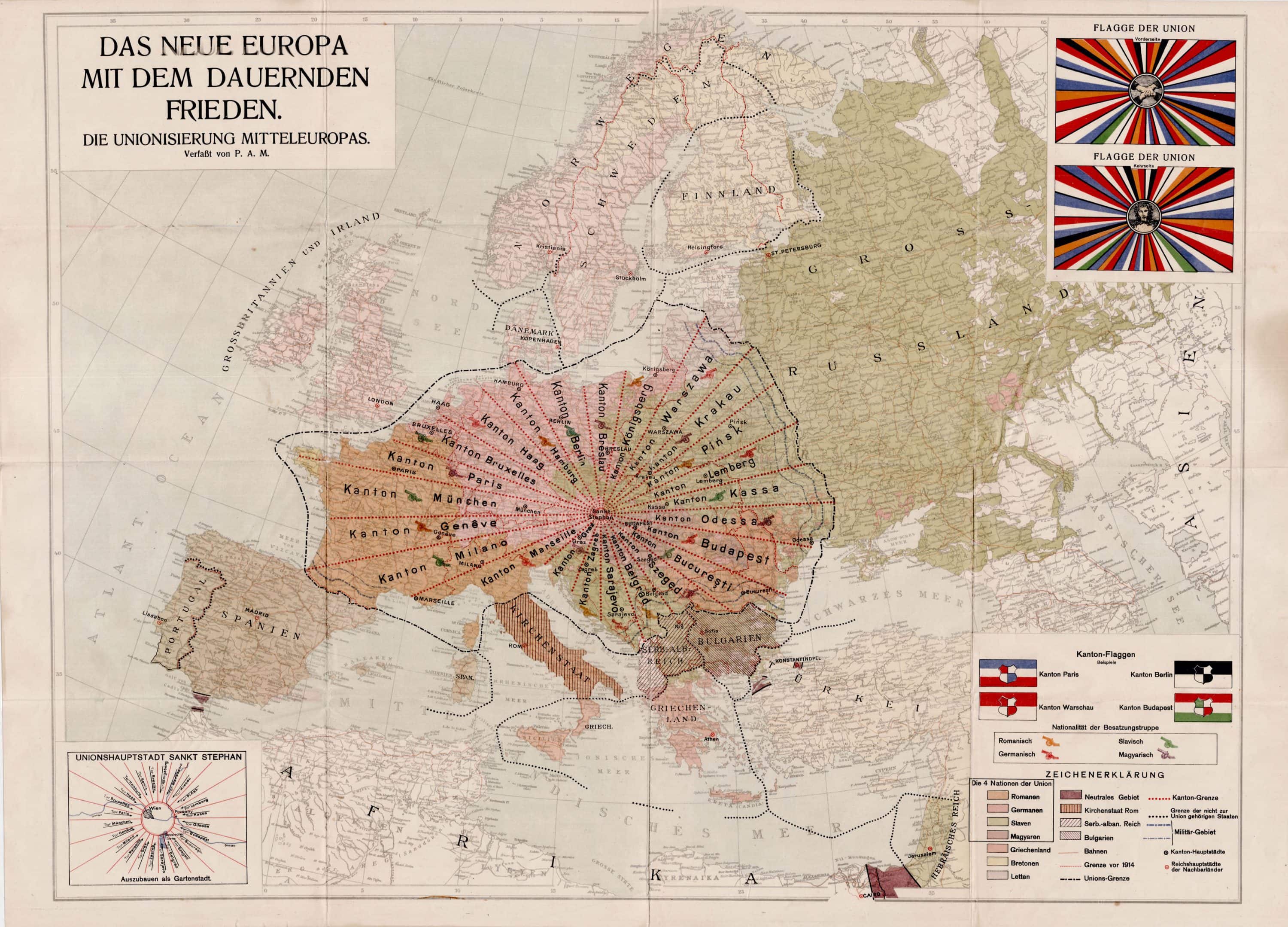
P. A. M. [P. A. Maas?], DAS NEUE EUROPE MIT DEM DAUERNDEN FRIEDEN. DIE UNIONISIERUNG MITTEL EUROPAS. ["The New Europe with Lasting Peace. The Unionization of Middle Europe."] [Vienna:] P. A. M[aas], [1920.] Lithograph printed in colors, 23 5/8"h x 31 ½"w plus margins.
[The following is adapted, with occasional modification, from the description of this map at Persuasive Maps: The PJ Mode Collection.]
A striking, enigmatic and very rare map illustrating a complex utopian scheme for a prototype European Union after the First World War. It was produced by "P.A.M.," an elusive figure, probably laid in loose to a 24-page pamphlet (not included here) describing his plan in elaborate detail.
The pamphlet, Die Unionisierung Mitteleuropas [:] Ein Wegweiser zum Dauerfrieden ("The Central European Union : A Guide to Lasting Peace") begins by challenging the Treaty of Versailles, which placed humiliating and ruinous conditions on the defeated Germany: "Does anyone really seriously believe that the consequences of the peace negotiations so far have secured eternal peace? Does anyone really seriously believe that the revenge of the individual peoples has been satisfied by the consequences of the present peace negotiations?" (p. 3)
The author then assures readers that
"In my project, the national states are surely torn apart, but they are, as it were, brought under one roof by creating sub-regions in which all nations are fused by or with time, a new human nature emerges from all the good and noble sides of every present nation, in which racial hatred does not prevail as before, but the love of the people prevails, and thus bestows happiness and blessings on all those who are counted as a unitary nation."
He expressly notes that the discussion to follow is "explained" by the accompanying map. As the map shows, the future Central European Union is to be composed of 24 "cantons," each a long, narrow, wedge named after its capital city. (p. 7) The odd wedge shape was adopted "only in order to create the most concessionary and fairest part of the whole territory of Central Europe," so that traditional disputes among European peoples "were solved and buried forever." (p. 10) The wedges were to meet at St. Stephen's Cathedral in Vienna, which city is renamed "Sankt Stephan" and designated the capital of the Union. The selection of Vienna as the capital is not explained apart from the author's opinion that "This I think of myself as a large, wide garden city, hygienically designed and expanded." (p. 10)
The Cantons cut across cultural and ethnic lines as well as traditional state borders.
"Throughout the Union, only four Nations are recognized: Romans, Germans, Slavs and Magyars. Each of these Nations, with the exception of the latter, is divided into different peoples, all belonging to the same tribe of the Nation. The Romans are found in France, Italy, Rumania—Germans in Prussia, Bavaria, Holland, Saxony, Austria, the Tyrol, etc.—The Slavs in Poland, Czechoslovakia, Moravia, Ruthenia, Croatia, Serbia, etc." (p. 14)
The four Nations are shown in different colors on the map, and each Canton includes people from at least two Nations. The Canton of Brussels, for example, includes Romans, Germans and Slavs.
The pamphlet offers many details on other aspects of the new Union. The President of the new European Union is to serve a three-year term, with the position to be rotated among the four Nations. Suffrage is to be extended to all those over age 20 may vote—with the exception of married women! (p. 14) Esperanto is to be the official language, while all overseas colonies are to be jointly owned (The pamphlet includes a separate map depicting much of Africa as a Union colony.) Other details include the flag of the Union, the front and back of which are shown at the upper right of the map.
Reasonably enough, the author and mapmaker appears to have had concerns as to how his work would be received.
"To many a reader this work may appear as the result of over-excited imagination; someday, though late, the knowledge of truth will gain the upper hand, and perhaps many things which have been stimulated by me here will be realized. This would be the most beautiful reward of my quite selfless, long, and elaborate intellectual work." (p. 3)
Choosing to remain anonymous for the moment, he added a note at the end of his Guide: "I have informed a Notary of my name, profession and role as author and editor of this work of peace, and it will be announced only when the four principal Nations in the Union have expressed their judgment publicly." (p. 24)
OCLC bizarrely identifies P.A.M. as the Port Autonome de Marseille. But it seems highly unlikely that a French port authority would commit the time and resources necessary to produce this work, and even more unlikely that if it had done so, it would have published its report in German—and designated Vienna as the capital of its proposed Union! In fact, the author was hiding in plain sight. The title page of the pamphlet indicates that it was published by the author, and that the publisher was Otto Maas' Sons ("Druck von Otto Maas' Söhne"). Thus P.A.M. was P.A. Maas, a son of Otto (Though he has not yet been named by the appointed notary, the four Nations having not to date "expressed their judgment publicly" on his visionary proposal).
Though OCLC locates a number of institutional holdings of the pamphlet, both it and the map are rare on the market. A review of the usual sources locates none either on the market or having appeared for sale in recent years.
The difference is those reflect national “identities” with a tenuous relationship to current politics or sociology. They scream, someone from the West who dug back far enough on the Wikipedia page about the region to find a trace of national identity they could anachronistically superimpose onto the modern country. Whereas this reflects a certain technocratic thinking, even radial division to resolve border/land issues with zero regard for national or ethnic identity.
Drawing borders across the balkans like that cannot possibly cause issues, can it?
Why would it? Is that area especially prone to border disputes?
I honestly can't tell if you're serious or not, so I'll just leave you with this:
https://en.m.wikipedia.org/wiki/Yugoslav_Wars
i'm extremely into radial kantonment. absolutely arbitrary insanity. the flag is weirdly cool looking
but i cannot abide wien as capital. booooooooo.
It reminds me of that WTYP episode where a company tries to build a train line that runs perfectly straight from New York to Ohio. The end result is a project that spends a fortune building these bridges and cut-outs through obstructing terrain, then runs out of money 1/10th of the way to the destination.
Oh I wish they got 1/10th of the way. The terrain they were dealing with was upper Indiana, and the most challenging project they faced was a small stream.
if they went west from Ohio to get to New York, I think I see the problem
I have a feeling that like 90% of Italy wouldn't be too happy with being the new Papal States, especially after they had to practically invade Rome to convince the Pope to join the rest of the peninsula.


